Watch our YouTube video below showcasing the incredible transformation of a tropical forest as it is ravaged by fire and then recovers over time, captured by satellite images.
After witnessing the incredible resilience of nature, continue reading to learn more about the scientific exploration behind this remarkable phenomenon below.
Introduction
Forest fires are a natural occurrence worldwide that can have significant consequences for the environment, air quality, and local economies. They can be caused by lightning strikes, human activities, or deliberate actions. After a forest fire, the land undergoes a crucial restoration process to support the revival of plant and animal life. This process involves two steps: recovery, which reintroduces the same plant species, and regeneration, which establishes a diverse and balanced ecosystem.
Geospatial technology, particularly remote sensing, has proven crucial in monitoring forests, identifying fires, managing post-fire activities, and tracking regeneration. Experts use remote sensing data integration with GIS-based mapping and field observations to define accurate fire perimeters, recognize high-risk areas, and gauge burn severity. Advanced remote sensing techniques enable researchers to track changes over time and adjust management practices as needed, providing timely and cost-efficient evaluations of vast, hard-to-access, or remote burn sites. This capacity makes geospatial technologies indispensable tools for effective forest fire management.
Context and Study Area
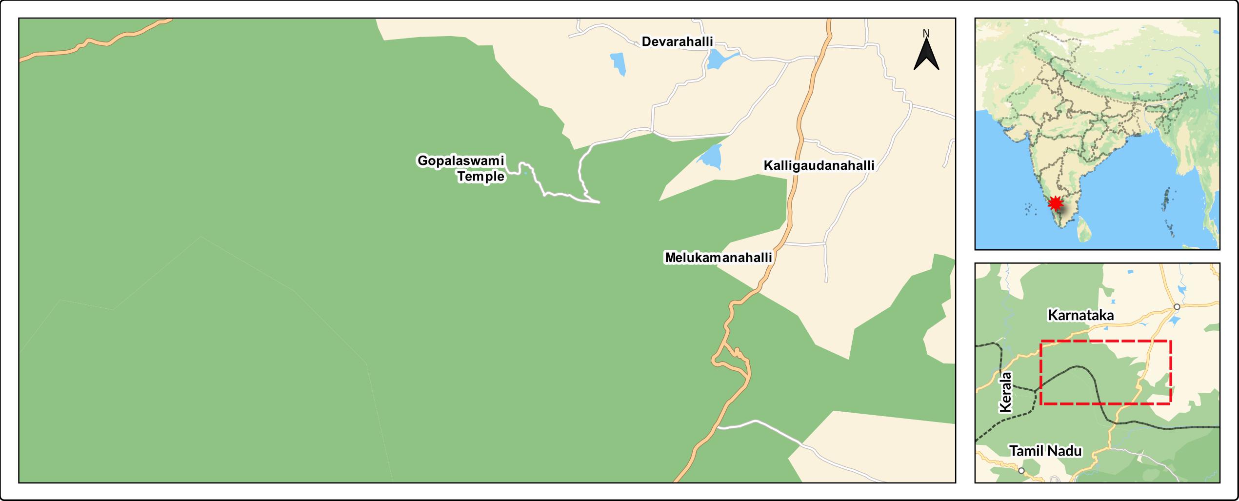
Bandipur Tiger Reserve in India is a vital-protected area, home to endangered species like Bengal tigers, Indian elephants, and Indian leopards. A forest fire occurred near the reserve from February 22nd to 26th, 2019, causing significant damage to wildlife and their habitat. Understanding the impact of this event on vegetation recovery is crucial for effective management and conservation efforts.
This case study focuses on investigating the post-fire vegetation recovery in the affected parts of Bandipur Tiger Reserve and National Park, as well as a small section of Mudumalai National Park in Tamil Nadu. By utilizing satellite imagery and geospatial technology, we aim to assess the extent and progress of vegetation regeneration following the fire. The study area encompasses coordinates ranging from 11°39’6.04” to 11°45’11.54” latitude and 76°28’18.31” to 76°40’53.48” longitude.
Through the evaluation of vegetation recovery using geospatial technology, this study underlines the significance of employing advanced tools to comprehend and address the impacts of such natural disasters. By gaining insights into the post-fire vegetation response, we can contribute to the preservation and management of critical protected areas like Bandipur Tiger Reserve, ensuring the continued survival of its diverse and endangered species.
Data Source and Analysis Tools
Sentinel 2 images obtained via ESA’s Copernicus program are used to assess burn severity and post-fire regeneration. The spatial resolution of the images used in this study ranges from 10 to 20 meters. The analysis and calculations for dNBR and NDVI were performed using the Google Earth Engine platform, while the maps were prepared using the software QGIS.
Burn Severity and regeneration Mapping Methodology
To investigate fire severity and post-fire vegetation regeneration, we use three remote sensing indices:
Index 1: Normalized Burn Ratio (NBR): This index utilizes near infrared (NIR) and short wave infrared (SWIR) bands to measure vegetation density and moisture content. The equation for computing NBR is:
NBR = (NIR – SWIR)/(NIR + SWIR)
Index 2: Differenced Normalized Burn Ratio (dNBR): Compares pre-fire and post-fire NBR values, providing insight into burn severity. The equation for computing NBR is:
dNBR = (NBR)pre-fire – (NBR)post-fire
Index 3: Normalized Difference Vegetation Index (NDVI): Assesses post-fire regeneration by measuring changes in vegetation greenness. The NDVI calculation is:
NDVI = (NIR – SWIR)/(NIR + SWIR)
While NBR and dNBR detect changes in vegetation reflectance caused by burning, assesses post-fire regeneration by detecting changes in vegetation greenness.
Now let’s have a closer look at the fierce fire that struck and how nature responded with stunning resilience.
The Study Area: One Day Before the Fire (21 February 2019)
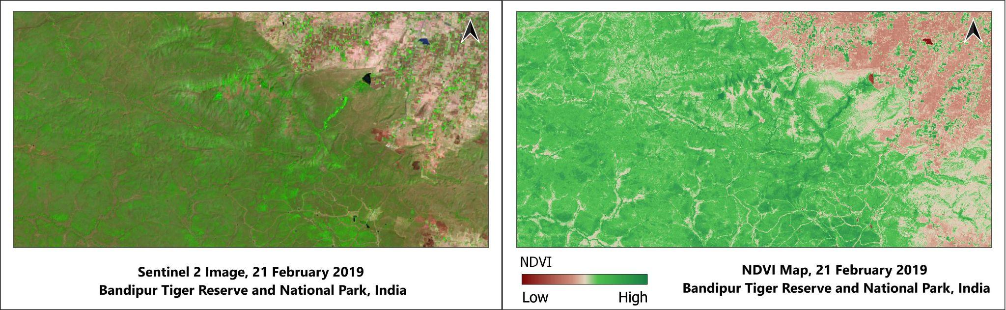
The provided satellite imagery displays the pre-fire false colour representation alongside the corresponding NDVI data, enabling visual analysis. As observed, much of the study area exhibits vegetative coverage, particularly forested regions, apart from small sections comprising non-vegetation features, such as settlements, open land and water bodies.
Dealing with Catastrophe: During the Fire (26 February 2019)
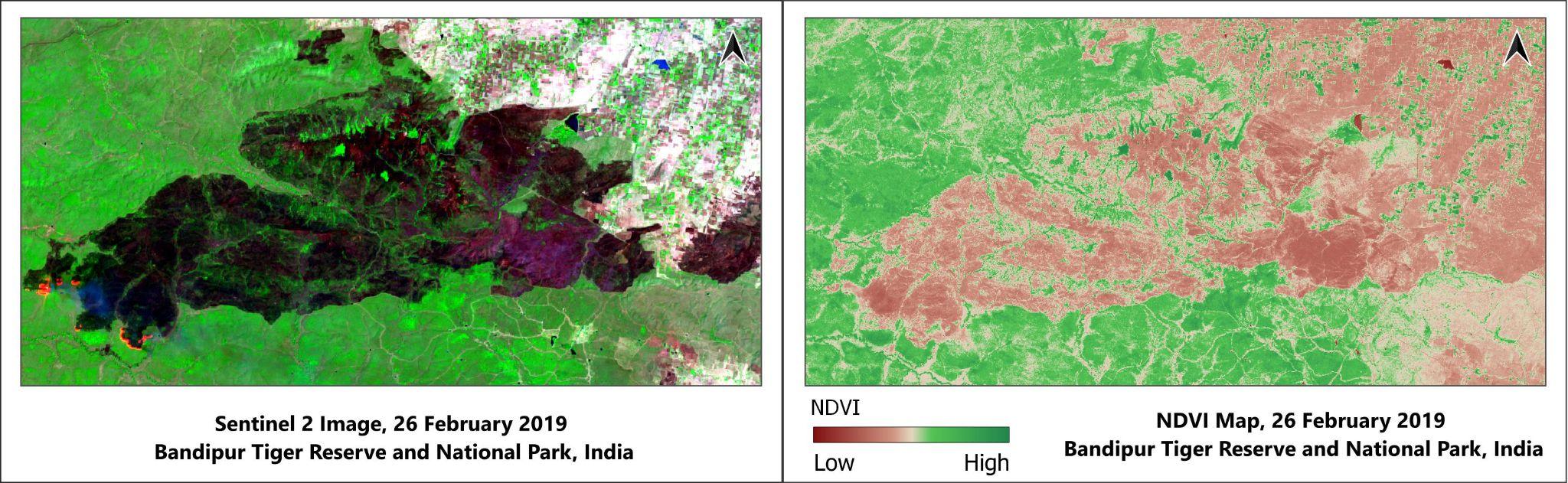
From the satellite images provided, it’s evident that the raging fire devastated much of the forest within the study area. There remain active fires in certain locations. Moreover, the Normalized Difference Vegetation Index (NDVI) maps demonstrate the extent of damage to the region’s greenery caused by the fire.
A comparison between the pre-fire NDVI map and the current one displays a considerable drop in high NDVI zones, indicating the severe effects of the fire. Areas previously rich in greenery, indicated by higher NDVI values, have now been reduced significantly. This decrease highlights the profound impact that this natural disaster has had on local ecosystems.
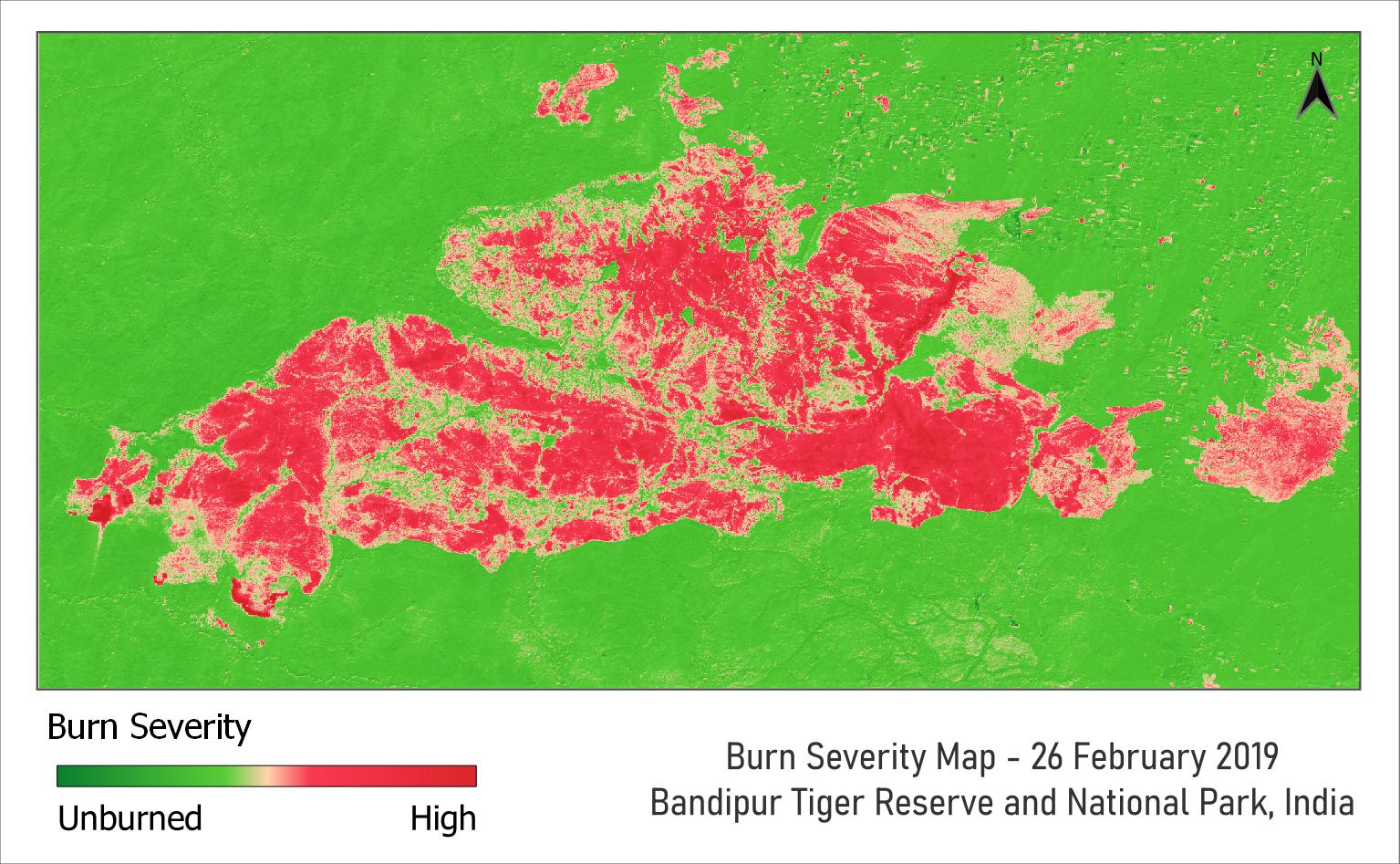
To analyze the burn severity caused by the fire, a burn severity map has also been created using the dNBR methodology. According to the study results, the fire had varying degrees of impact on the study zone, which covered a total area of 260 square kilometers. Approximately 29% of the study zone, equivalent to about 75 square kilometers, experienced the effects of the fire. On the other hand, around 71% of the study zone, equivalent to 185 square kilometers, remained unaffected by the fire.
From Ashes to Hope: Recovery After One Month (28 March 2019)
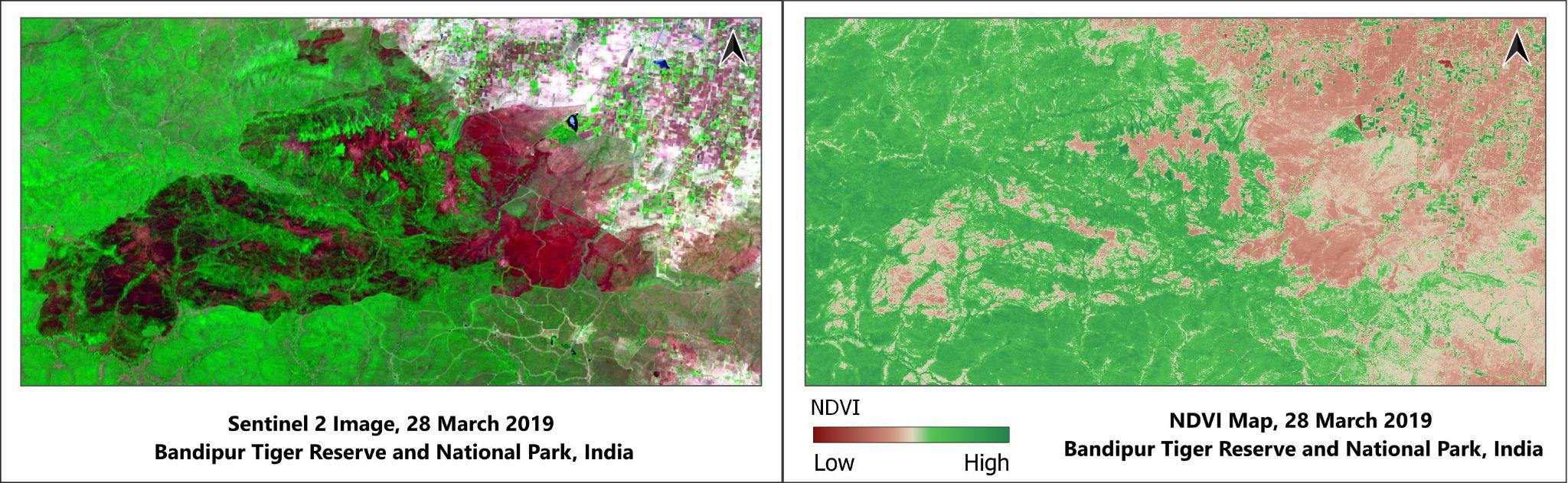
One month after the tragic wildfire, signs of renewal are already visible throughout the destroyed terrain. A closer examination of the Normalized Difference Vegetation Index (NDVI) map reveals substantial increases in greenness in most parts of the impacted regions. Fresh shoots of grasses and shrubs have emerged from the scorched earth, offering hope for the revival of the once-vibrant ecosystem. These early indicators of regrowth and the emergence of new vegetation serve as promising developments, illustrating the incredible resilience of nature and the rapid onset of recovery following such catastrophic events.
Healing in Action: Recovery After Two Months (27 April 2019)
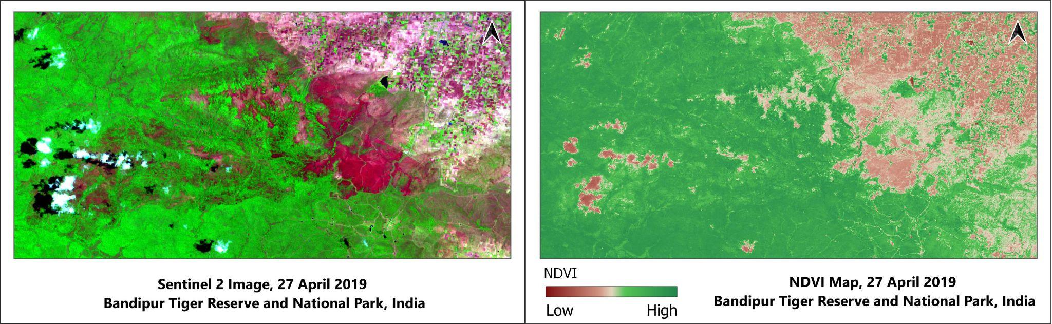
Two months after the destructive wildfire, the region has shown impressive progress in its journey toward restoration. From analyzing satellite images and NDVI data, it becomes evident that much of the devastated ground has sprouted fresh greenery.
Meanwhile, the influence of clouds must be considered when interpreting these findings. Since optical remote sensing sensors rely on direct sunlight to gather information from the ground below, any interruption – such as cloud cover – may lead to incomplete data collection and reduced NDVI measurements. Hence, the presence of clouds can account for lower NDVI readings within the designated research area.
Connecting with Nature’s Journey: Recovery After Three Months (27 May 2019)
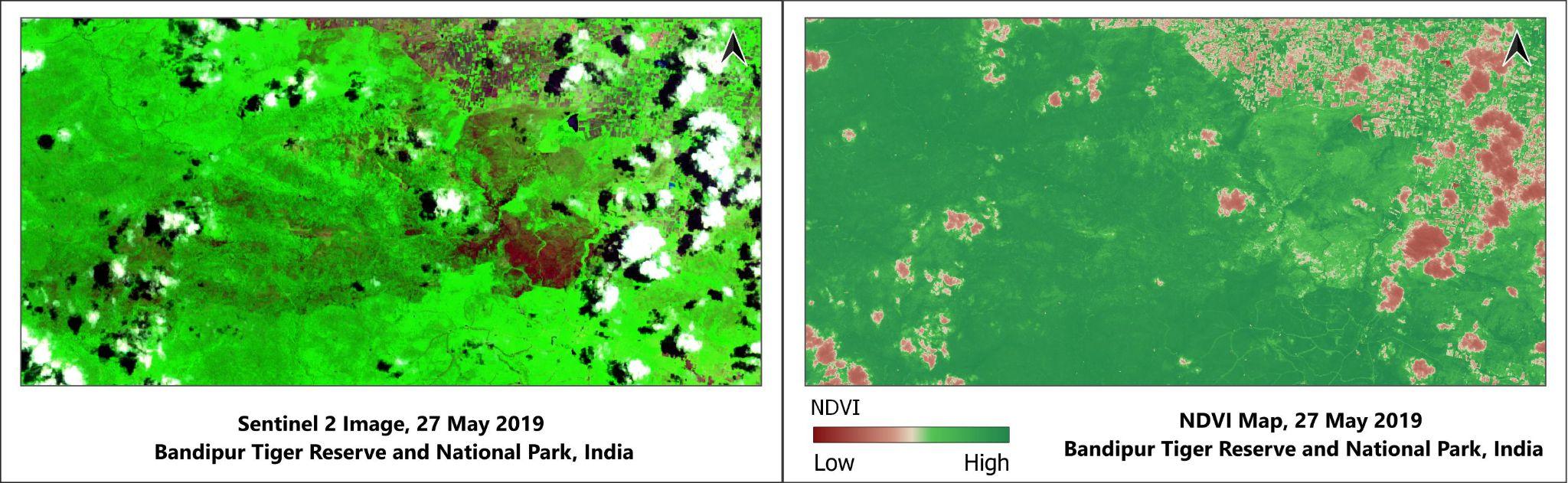
Three months have passed since the devastating wildfire ravaged the landscape, leaving behind a scarred and barren wasteland. But now, as we examine the satellite imagery and NDVI measurements taken recently, we see a remarkable transformation unfolding before us. While some areas are slower to recover due to severe damage or difficult terrain, most affected regions are experiencing a surge in new life.
Although cloud cover has caused a decrease in NDVI values in some areas, this does not necessarily mean that there is no vegetation in those areas. Cloud cover can obscure accurate measurement of NDVI values, making it difficult to assess the true extent of vegetation recovery. Nonetheless, the resilience of nature shines through as vegetation continues to push through adversity, demonstrating its remarkable ability to regenerate and thrive.
Flourishing After the Flames: Recovery After Ten Months. (18 December 2019)
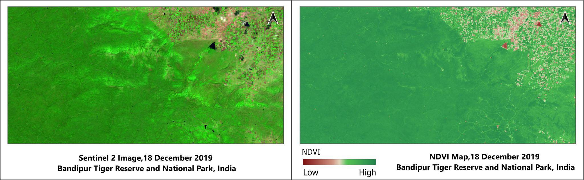
Ten months after the wildfire ravaged the landscape, we see remarkable signs of recovery and flourishing in the affected areas. Evaluating satellite imagery and NDVI data reveals that most of the affected areas have fully regrown and appear even healthier than they did prior to the blaze.
Comparisons between NDVI and image data from the initial three months after the fire and the present showcase the full extent of the regeneration. The ample rainfall received during the monsoon season played a crucial role in promoting the rapid recovery of the ecosystem. All these factors combined demonstrate the robustness of nature and its capacity for renewal, even in the face of significant adversity.
Restoring Balance: The Continuing Journey After 1 year(18 December 2019)
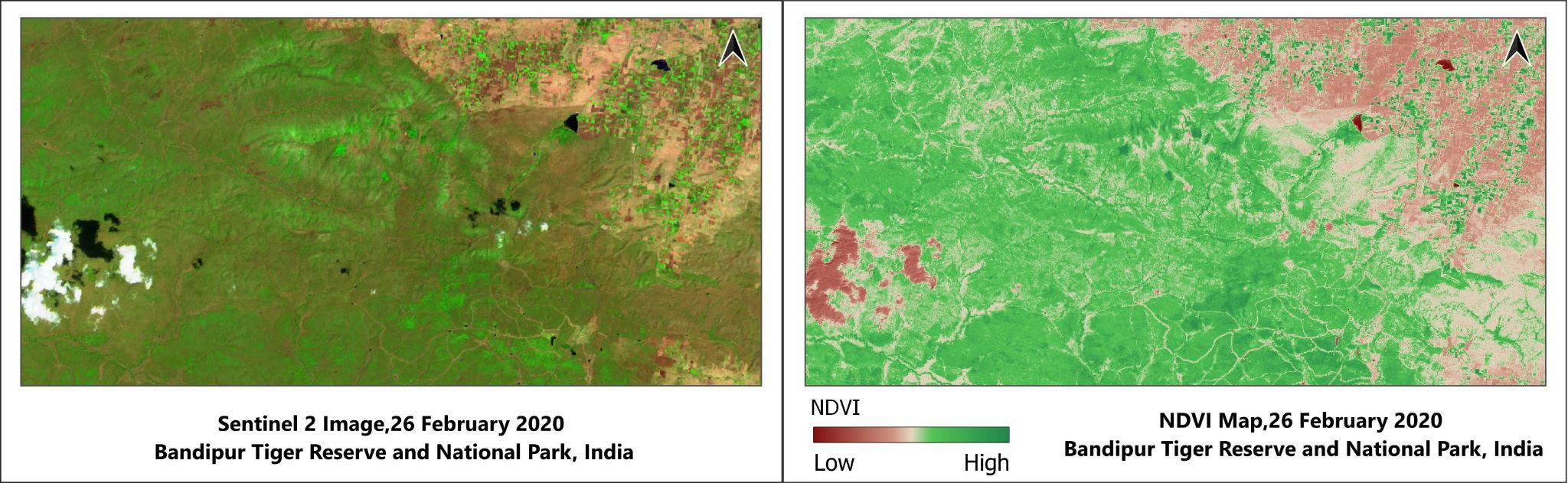
One year has passed since the fateful fire swept through the region, leaving behind scorched earth and devastated communities. As February arrives, the NDVI values have significantly decreased compared to the peak seen in December as winter progresses. However, despite this decrease, the forest is slowly but surely starting to regain its former vitality, resembling the thriving ecosystem that existed before the fire. Although the journey toward full restoration remains fraught with obstacles, the renewal of the ecosystem serves as proof positive of the resiliency inherent within nature itself.
Conclusion
The wildfire aftermath in India’s Bandipur Tiger Reserve reveals the remarkable resilience of nature and the valuable insights provided by remote sensing technology. Satellite imagery and NDVI measurements reveal changes in vegetation and identify fire-prone areas within the forest, providing valuable insights to manage and prevent wildfires. However, it is important to acknowledge that remote sensing is limited in fully capturing the internal damage and healing processes occurring within the forest.
In conclusion, it is important to recognize that remote sensing, despite its extensive perspective, may not fully capture or comprehend the intricate internal damage and healing dynamics within the forest. To gain a comprehensive understanding of forest health, it is essential to complement remote sensing data with on-the-ground assessments. By integrating these approaches and employing advanced analytical techniques, we can make informed decisions and implement targeted mitigation measures to effectively protect and restore our forests. Embracing a holistic approach that combines remote sensing with a deeper understanding of the forest’s dynamics will ensure the health, sustainability, and resilience of our forests for future generations.

The retrieval of natural resources is visually deciphered through this study..
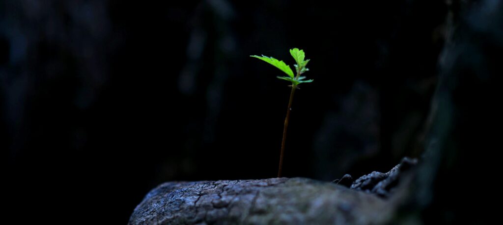
How beautiful….nature’s resilience.
Layman also came to know how efficient GIS tool in tackling problems.
Excellent 👌
The scope of using geospatial techniques in disaster management referring forest fire and it’s impact in Land Cover changes and air quality is explained in this paper in very good language..The author explaining the facts nicely with technical support.Expecting more papers
Congratulations and all the very best wishes
I am sharing this with my students